

![[RAPHAEL]. Seconda parte delle logge di Rafele nel Vaticano che contiene](https://bbys.imgix.net/1663/7ec021b255c33d4264c863a42957b28f46451b82f30cb5e0eca40915792e8a0c.jpg?auto=format&w=3840&q=75)







OCT 23 | 8:00 AM

All auctions / Books, Maps & Manuscripts / Africa - Morocco Algeria; Cellarius - Mauretania et Numidia - 1732

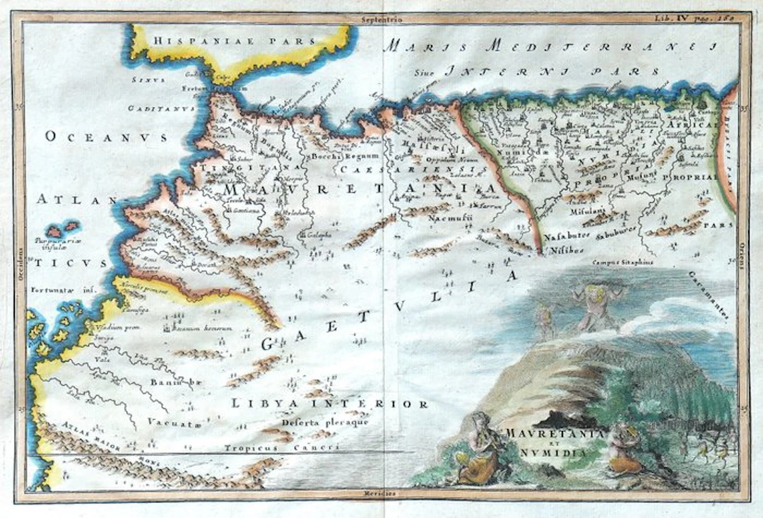
Technical sheet Title: Mauretania et Numidia; map of ancient Mauretania and Numidia, with part of the Proconular Africa and internal territories. Author: Christoph Cellarius, Latinized name of Christoph Keller (1638–1707). Publisher: Johann Friedrich Gleditsch, publisher; printer not identified. Place: Leipzig, Germany. Period: first half of the 18th century. Technique: copper engraving on copper, with burin hatching and manual colorization of an era not confirmed. Support: laid paper. Dimensions: plate 20.5 × 31 cm; sheet 25 × 35 cm. Inscriptions: title in the cartouche at lower right; reference “Lib. IV pag. 168” at upper right; indications of the cardinal points along the border. Composition: single plate with central editorial fold, taken from Notitia orbis antiqui, sive geographia plenior (...). Verso: white. Description Ancient northwest African geographical map compiled by Christoph Cellarius for the Notitia orbis antiqui. The plate depicts Mauretania and Numidia, extending the depiction to part of the Proconular Africa and to the interior regions indicated as Getulia and Libia Interior. The depicted territory corresponds mainly to the present-day Morocco, Algeria, and Tunisia. To the north is shown part of the Iberian Peninsula, separated from the African coast by the strait named Fretum Herculeum; to the west are represented the Fortunate Isles, associated with the Canary Islands archipelago. The map features rich Latin toponymy, with cities, peoples, rivers, and territorial divisions of the ancient world. Mauretania Tingitana and Mauretania Caesariensis are distinguished, while the relief is rendered through small mountainous profiles. The gridded scale and the indications of the cardinal points complete the geographic setting. Manual colorization highlights territorial borders and coasts, accompanied by blue shading. In the bottom right, the title is inset in an articulated figurative cartouche, set in a rocky landscape with figures, animals, and a standing figure with raised arms. The decorative apparatus complements the didactic function of the map with the decorative taste of European cartography of the period. Historical-artistic note Christoph Cellarius was a German philologist, historian, and geographer, whose work contributed to the systematic study of the geography of the classical world. The Notitia orbis antiqui brings together descriptions and maps intended to reconstruct places, regions, and territorial designations of antiquity. The Mauretania et Numidia plate belongs to this tradition of historical cartography: it represents North Africa through ancient nomenclature and partitions, offering a tool for reading classical authors and studying Roman geography. Condition Report Copy with light browning of the paper and sporadic small stains. Slight waviness of the support and modest edge wear. Margins preserved on all four sides. Clear impression and legible coloring. Verso white, with transparency of engraving and color.
Estimate:£12.69
To the auctionView all items fromCatawikiorBooks, Maps & Manuscripts
Estimate:
£12.69

OCT 23 | 8:00 AM


OCT 27 | 4:00 PM


OCT 17 | 10:00 PM
Bring your auction to collectors worldwide!
Get listed nowBy subscribing, you are agreeing to the privacy policy. Unsubscribe anytime.
Barnebys HQ
Brahegatan 10
BOX 5038
114 37 Stockholm
