



OCT 17 | 10:00 PM

All auctions / Books, Maps & Manuscripts / Germany - The County of Mansfeld: the Mansfeld Land

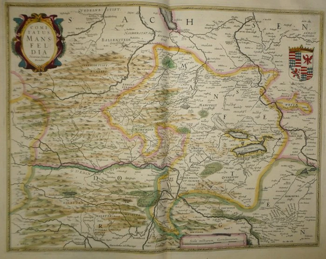
Ancient map engraved on copper and hand-enhanced from the county of Mansfeld by Hondius, published in 1633 in the Mercator-Hondius atlas. There is an oval cartouche with scrolls bearing the inscription “Henricus Hondius Excudit.” The crowned coat of arms of the Counts of Mansfeld, with bands, diamonds, eagle and lion, occupies the upper right corner. The territory is bordered by a yellow frame. The neighboring principalities (Halberstadt, Anhalt, Stolberg, Querfurt, Wettin) are indicated. The lakes, woods, hill-reliefs, waterways and numerous vignettes of towns and castles enliven the map. An imperial German mile scale accompanied by a compass appears at the bottom. The coloring is period-appropriate. The French text “La Comte de Mansfelt” (pp. 469 and 472), adorned with a bandeau, a historiated initial and a drop cap, accompanies the map. - Dimensions: sheet 56 x 47.5 cm; map plate 46.9 x 35.3 cm - Condition: Good overall for a map of this era. There is a central vertical crease, two small holes and damp spots in the upper margin and light stains. See photos for details. Atlas Mercator-Hondius - The atlas called “Mercator-Hondius” continues the work of Gerard Mercator, whose copper plates were bought back by Jodocus Hondius in 1604. This 1633 French edition is signed by his son Henricus Hondius and his son-in-law Joannes Janssonius, who added new maps. Henricus Hondius – Henricus Hondius (1597-1651), engraver and publisher of maps in Amsterdam, was the son of Jodocus Hondius. The latter acquired in 1604 the copper plates of Gerard Mercator (1512-1594). Henricus continued the atlas edition, often associated with Johannes Janssonius, hence the designation “Atlas Mercator-Hondius.”
Estimate:£127.14
To the auctionView all items fromCatawikiorBooks, Maps & Manuscripts
Estimate:
£127.14
OCT 17 | 10:00 PM


Bring your auction to collectors worldwide!
Get listed nowBy subscribing, you are agreeing to the privacy policy. Unsubscribe anytime.
Barnebys HQ
Brahegatan 10
BOX 5038
114 37 Stockholm
